Introduction
LiDAR, an acronym for Light Detection and Ranging, has emerged as a transformative technology, revolutionizing various fields, including agriculture, environmental monitoring, and archaeology. By harnessing the power of laser pulses, LiDAR systems meticulously map the Earth’s surface, generating high-resolution digital surface models, terrain data, and elevation profiles. This article delves into the captivating realm of LiDAR, exploring its diverse applications when integrated with drones.

Unveiling the Essence of LiDAR
LiDAR operates on the principle of emitting rapid laser pulses in a series of precisely defined directions. The time it takes for each laser pulse to reflect from a target and return to the LiDAR scanner is meticulously measured, enabling the reconstruction of the distance and direction to the surface surrounding the scanner. By mounting a LiDAR scanner onto a mobile platform like a drone, it becomes possible to 3D map vast areas as the drone traverses the terrain.
LiDAR’s Soaring Applications on Drones
The integration of LiDAR with drones has opened up a plethora of applications, transforming diverse industries and propelling innovation:
1. Accident Scene Investigation
LiDAR’s active nature, utilizing ultraviolet or near-infrared light to image objects without relying on external illumination, makes it ideal for accident scene investigation. Equipped with LiDAR, drones can effectively map accident sites, even at night, providing detailed 3D models and accurate information for forensic analysis and evidence collection. This expedites the cleanup process, minimizes traffic disruptions, and reduces costs associated with accident response.
2. Forestry and Agricultural Surveys
The vastness of forests poses a significant challenge for management. Traditional forest inventory methods are time-consuming and inefficient, often resulting in inaccurate estimates. LiDAR-equipped drones revolutionize forestry surveys, enabling precise measurement of canopy heights, tree cover, and tree density. Additionally, individual tree positions and heights can be determined, eliminating the shortcomings of traditional methods. LiDAR’s ability to operate independent of natural light further enhances its utility, allowing surveys even under unfavorable conditions.
3. Agricultural and Landscaping Applications
In large-scale farming, 3D landscape mapping plays a crucial role in designing effective irrigation systems. For instance, in extensive rice paddies, accurate knowledge of the terrain is essential for constructing effective levee systems. LiDAR drones efficiently collect this data, enabling precise irrigation management and optimizing water usage.
4. Terrain Modeling
LiDAR offers significant cost savings compared to traditional ground-based surveying methods. By employing a technique that detects remote objects, including foliage, shrubs, trees, and even grass, LiDAR analyzes the reflected laser pulses from object surfaces to determine their position, velocity, and other characteristics. This provides a 3D terrain profile that ground operators can utilize for various purposes.
5. Power Line Inspection
LiDAR-generated point clouds provide detailed information about power lines and pole-to-pole distances. This enables surveyors to analyze the intricate structure of power line corridors, including vegetation, roads, and buildings, identifying potential hazards and ensuring grid safety.
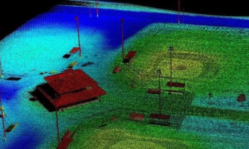
6. Topographic and Bathymetric Surveys
Topographic and bathymetric surveys, often covering vast areas, are traditionally conducted using aircraft and helicopters. Terrestrial LiDAR utilizes near-infrared lasers to map land surfaces, while bathymetric LiDAR employs green light to penetrate water, measuring the seabed and riverbeds.
7. Archaeological Exploration
Traditional surveying methods for extensive historical sites could take years to complete. However, with the advent of LiDAR technology, entire cities can be mapped in 3D within minutes. This has revolutionized archaeological research, enabling the rapid and detailed documentation of ancient sites, revealing hidden structures and providing insights into past civilizations.
8. Mining Applications
The complex terrain of mines often poses challenges for high-precision surveying using conventional methods like total stations and GPS. The advent of digital mining has increased the demand for spatial 3D information, and 3D visualization has become a cornerstone of digital mine management. However, traditional surveying methods struggle to provide the data required for 3D digital mines. Rapidly developing 3D laser scanning technology offers a solution, providing high-resolution, high-sampling-rate, non-contact measurements, making it ideal for capturing spatial 3D information of complex mine surfaces and high-hazard areas.
Conclusion
LiDAR’s integration with drones has transformed various industries, offering unprecedented capabilities for data collection, analysis, and visualization. From accident scene investigation to archaeological exploration, LiDAR drones are revolutionizing our understanding of the world around us, opening up new avenues for innovation and progress. As technology continues to advance, LiDAR’s role in drone applications is poised to expand even further, shaping the future of diverse fields and driving groundbreaking discoveries.

