LiDAR sensors and radar systems are two major competitors in the autonomous driving domain. Determining which technology is better suited for autonomous vehicle navigation is a challenging task that requires a detailed analysis of their advantages and limitations. Both systems have unique strengths and weaknesses.

LiDAR vs. General Radar: Key Differences
| Feature | Radar | LiDAR |
|---|---|---|
| Detection Accuracy | Lower | Higher |
| Detection Range | Longer | Shorter |
| Anti-interference Ability | Weaker | Stronger |
| Environmental Impact | Smaller | Larger |
| Cost | Lower | Higher |
2.1 Operating Principles
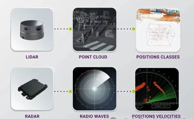
LiDAR sensors use lasers to measure distances, creating precise, high-resolution maps of the area surrounding the vehicle. LiDAR technology has gained popularity in recent years due to its ability to enhance the accuracy of autonomous driving-related tasks and generate real-time precise 3D object images. Moreover, LiDAR technology has become a popular choice among autonomous vehicle manufacturers due to its ability to capture the finest details, such as road textures or pedestrian shapes.
General radar also plays a significant role in automotive safety systems. It utilizes radio waves to detect objects and measure their size, speed, and direction. While the details provided by radar may not be as rich as those of LiDAR, it still offers several advantages that make it a compelling choice for autonomous vehicle navigation. One reason is that radar is less affected by weather conditions such as fog, rain, or snow compared to LiDAR. Additionally, radar systems are typically cheaper and consume less power than LiDAR counterparts.
2.2 Structure and Operation
Land-based and airborne LiDAR systems employ digital cameras or other imaging sensors to capture the reflected light from the laser beam. The data collected by the sensors is then processed into point clouds, which can be used to create digital maps and other applications. In contrast, radar systems convert the reflected microwaves into images on a screen or computer display. General radar cannot measure distances as precisely as LiDAR does because it cannot determine the distance of an object based on its energy reflection.
Another distinction lies in the operational range of the two technologies. LiDAR systems typically have a shorter detection range than radar systems but can provide more accurate measurements at close range. Radar systems, on the other hand, have a longer detection range and are better at detecting objects at a distance. Additionally, LiDAR is more expensive and requires a clear line of sight, while radar can detect objects through fog, rain, and other obstacles.
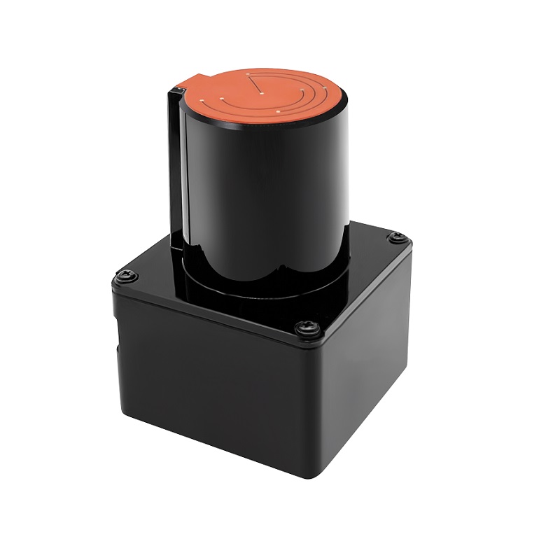
POE lidar
Challenges of Using LiDAR and General Radar
3.1 LiDAR
Despite its exceptional performance, LiDAR faces certain challenges when applied to autonomous vehicles. One of the most significant hurdles is the cost of LiDAR technology. For many automakers, LiDAR sensors remain too expensive, despite prices gradually decreasing over the past few years. Compared to lower-priced radar systems, LiDAR still lacks an advantage. This has prompted some companies to explore alternative approaches, such as using multiple, lower-cost LiDAR sensors to provide the same precision as a single high-end device.
Another potential issue is that LiDAR technology can be susceptible to interference from other light sources. It is not hard to imagine that in today’s world of proliferating autonomous vehicles, several LiDAR-equipped cars operating in close proximity might interfere with each other’s lasers. This could make the sensors too “noisy” to accurately map the surrounding environment.
3.2 General Radar
General radar systems have their own difficulties. While radar systems are less affected by environmental variables, they sometimes struggle to distinguish between stationary objects and slow-moving objects. In some situations, such as navigating through crowded parking lots or approaching parked cars at intersections, this can make it challenging for radar-equipped vehicles to effectively assess their surroundings.
4. Data Requirements for LiDAR and General Radar
4.1 LiDAR
LiDAR can create 3D point clouds, which are digital representations of the physical world as seen by artificial intelligence systems. These 3D point clouds need to be annotated using more advanced methods ranging from cuboids and polygons to polytopes. The latter can provide ground truth annotations of landmarks, road surfaces, and lane markings to the system. Traffic scene semantic segmentation is also necessary, which aims to identify and annotate different objects and parts in the 3D scene.
4.2 General Radar (Continued)
By fusing data from different sensors, a more comprehensive and accurate understanding of the environment can be achieved.
5. Applications
LiDAR, an acronym for Light Detection and Ranging, utilizes laser pulses to measure distances and generate high-resolution 3D models of objects and surroundings. Its precision and ability to create detailed 3D representations make it ideal for applications that demand intricate environmental mapping and accurate object detection.
Radar: Sensing the World with Radio Waves
Radar, on the other hand, employs radio waves to detect and locate objects. While it offers lower resolution compared to LiDAR, radar excels in its ability to operate under all weather conditions, including rain, fog, and dust. Additionally, radar’s longer range makes it suitable for applications requiring coverage over vast areas.
Applications of LiDAR and Radar
The unique characteristics of LiDAR and radar translate into a diverse range of applications:
LiDAR Applications:
Precise Distance Measurement: LiDAR’s exceptional precision makes it ideal for applications that require accurate distance measurements, such as topographic surveys and construction site monitoring.
Complex Scene Mapping: LiDAR’s ability to create detailed 3D models is particularly valuable for mapping complex environments, such as intricate architecture, dense urban landscapes, and cluttered industrial settings.
Traffic Planning: LiDAR plays a crucial role in traffic planning and management, enabling the creation of detailed traffic flow models and the identification of potential congestion points.
Radar Applications:
Traffic Control: Radar’s ability to detect and track moving objects makes it essential for traffic control systems, enabling the monitoring of traffic flow, identifying potential hazards, and implementing dynamic traffic signal timing.
Collision Avoidance Systems: Radar is widely employed in collision avoidance systems for vehicles, providing real-time detection of obstacles and initiating braking or evasive maneuvers to prevent accidents.
Tracking and Detection: Radar’s long-range sensing capabilities make it suitable for tracking and detection applications, such as air traffic control, weather monitoring, and surveillance systems.
Choosing the Right Technology
The choice between LiDAR and radar ultimately depends on the specific application requirements:
LiDAR:
- Prioritize high-resolution 3D mapping and accurate object detection
- Suitable for applications in clear weather conditions
Radar:
- Favor all-weather operation and long-range sensing
- Ideal for applications requiring wide-area coverage
Conclusion
LiDAR and radar, each with its unique strengths, have propelled advancements in various fields, particularly in the development of autonomous vehicles. LiDAR’s high-resolution 3D mapping and accurate perception capabilities are indispensable for autonomous driving, while radar’s all-weather operation and long-range sensing complement these capabilities. As technology continues to evolve, LiDAR and radar are poised to play an even more prominent role in shaping the future of autonomous vehicles and various other applications.

