
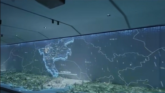
In the fast-evolving real estate industry, the need for innovative ways to present property developments is growing. Real estate developers are now turning to LiDAR (Light Detection and Ranging) technology to transform traditional sand table displays into interactive, immersive experiences. By integrating LiDAR-based radar technology with projection systems, real estate sand tables are not just static models—they’re becoming dynamic, real-time visualizations that engage users in ways that were previously unimaginable.
What is LiDAR Projection Technology?
LiDAR technology works by emitting laser beams to measure distances and generate high-precision 3D maps of an environment. In real estate sand tables, LiDAR radar sensors detect and interpret a user’s gestures, locations, or movements without physical contact. The technology then feeds this data to a processing system, which triggers corresponding changes on the sand table, such as lighting adjustments, projected data, or even dynamic animations of the property.
How Does It Work?
The process of creating an interactive LiDAR-based real estate sand table can be broken down into three main components: hardware configuration, software algorithms, and interactive design.
1. Hardware Configuration
Radar Sensors: High-precision radar modules (such as those from TI’s IWR6843) are installed above or around the sand table to create a radar field that covers the entire interaction area.
Data Processing Unit: Embedded processors, such as Raspberry Pi or NVIDIA Jetson, handle the real-time processing of radar data. These units ensure seamless interaction by quickly interpreting gestures or hand movements.
Interactive Sand Table System: This includes LED lighting systems, projectors, and mechanical devices that physically respond to radar inputs. The sand table is synchronized with these components to create a cohesive, interactive experience.
2. Software Algorithms
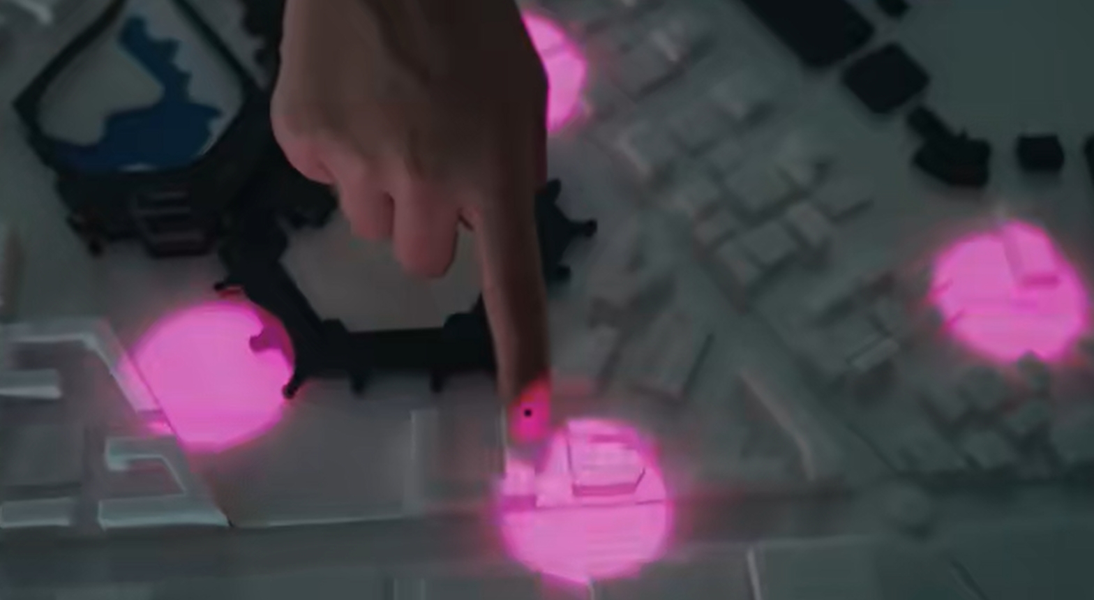
Gesture Recognition: Machine learning algorithms, such as Convolutional Neural Networks (CNN), help recognize different hand gestures or movements. For example, a swipe can change the perspective of the model, while a pinch gesture can zoom in on specific areas of the property.
Coordinate Mapping: The radar data is mapped to the digital coordinates of the sand table model, allowing users to interact with the model intuitively. The system can provide real-time updates, such as changing views of buildings or highlighting specific properties when a user points at them.
Real-Time Rendering: Tools like Unity3D or Unreal Engine are used to render real-time, dynamic projections. These can simulate sunlight, shadows, traffic patterns, or environmental changes, bringing the digital sand table model to life in ways traditional methods cannot.
3. Interactive Design
Basic Functions: The basic interactive features include controlling lighting effects, revealing building layouts via projections, or displaying real-time data when a user hovers their hand over certain regions. For example, hovering over a residential area might display information such as square footage, amenities, or pricing.
Advanced Functions: For a more collaborative experience, multiple users can interact with the sand table simultaneously, planning layouts, or even designing roads and infrastructure in real time. This level of interaction fosters a more engaging and personalized user experience.
Voice & Gesture Fusion: The integration of voice commands adds another layer of interactivity. For example, a user could say “Show me the commercial area” while simultaneously drawing an outline with their hand to highlight the desired region. This blend of voice and gesture interaction offers a seamless and intuitive user interface.
Real-World Applications
1. Property Demonstrations
During real estate presentations, customers can use their hands to navigate around the sand table, switching between different building views or zooming in on specific properties. This creates a sense of control and immersion that’s difficult to replicate with traditional models.
2. Planning Simulations
LiDAR-enabled sand tables allow users to simulate urban planning, such as drawing roads, adjusting land usage, or experimenting with zoning. The system automatically updates the projections to show the impacts of these changes, allowing developers and clients to explore different scenarios in real-time.
3. Data Visualization
By hovering their hands over certain areas, users can instantly access key data points about a property—such as price, floor plans, or surrounding amenities. This level of instant information enhances decision-making and increases user engagement.
Advantages of LiDAR-Enhanced Sand Tables
Non-Contact Interaction: Users can interact with the sand table without physically touching it, creating a more hygienic and intuitive experience.
High-Precision Tracking: LiDAR offers exceptional precision, enabling detailed gestures like rotating the model, zooming in, or selecting specific objects with minimal delay.
Immersive and Engaging: The combination of dynamic projections, high interactivity, and real-time data makes the experience far more engaging compared to traditional sand tables or static models.
Challenges and Considerations
Despite the clear advantages, implementing LiDAR-based interactive sand tables does come with challenges:
Cost: The radar modules and custom development can be costly, especially for high-end LiDAR sensors and processors. Additionally, integrating complex software algorithms can require a substantial investment in R&D.
User Interaction Complexity: It’s essential to fine-tune the system to avoid unintentional gestures or environmental interference (such as multiple people standing near the table). Ensuring smooth, intuitive interaction is key to maintaining a seamless user experience.
Technical Maintenance: Regular calibration and maintenance are necessary to ensure optimal performance, as the system relies on precision hardware and sophisticated algorithms.

The Future of Real Estate Sand Tables
Looking ahead, there are a few exciting trends that may shape the future of interactive real estate displays:
Augmented Reality (AR) Integration: Combining LiDAR radar sensors with AR glasses will allow users to interact with both virtual and physical elements of the real estate sand table, offering even deeper immersion.
AI-Enhanced Personalization: With the integration of AI, the system could analyze user behavior and preferences, offering personalized property recommendations or visualizing customized scenarios.
Smart Cities Simulation: The future of LiDAR-enhanced sand tables may extend beyond real estate to urban planning, where entire cities are modeled and simulated for traffic management, infrastructure development, and even emergency response strategies.
Conclusion
By incorporating LiDAR technology, real estate sand tables have evolved from simple physical models into powerful interactive tools. The combination of radar sensors, gesture recognition, and real-time projections provides a more immersive and engaging way to experience and visualize property developments. As technology continues to advance, these interactive displays will only become more sophisticated, offering new opportunities for developers, clients, and planners alike.

